 Skip to main content

Supporting safe navigation is at the heart of what we do
At the UK Hydrographic Office (UKHO), we turn marine geospatial data into charts, publications and expertise that support decision making across the globe.
Working with international partners, we collect, process and share hydrographic and marine geospatial data from seabed to surface. This data informs critical decisions about our oceans and underpins our Admiralty portfolio of navigational products and services.
Relied upon by mariners, shipping companies and defence users worldwide, our Admiralty products support safe, efficient and compliant navigation. Today, more than 90% of large ships trading internationally carry Admiralty products on board.
As well as supporting navigation today, we also work internationally to advance seabed mapping, share expertise, and help shape the standards and technologies that will guide the maritime operations of tomorrow.
About our organisation
Our vision is to be a beacon for quality, innovative navigation solutions, trusted by partners and customers worldwide. With over 225 years of expertise, everything we do is underpinned by our purpose, to support safe, secure and thriving oceans.
How we work
The UKHO is an executive agency of the UK Ministry of Defence (MOD) and operates as a trading fund. We are self-funded through the sale of our Admiralty products and services, enabling us to deliver our public task at no additional cost to the taxpayer.
Based in Taunton, Somerset, we employ around 900 staff, including specialists across hydrography, navigation, defence, technology and more. We are led by our Executive Leadership Team, supported by the UKHO Board.
Our public task
Our public task outlines the UKHO’s responsibilities as outlined in our Framework Document. As part of our public task, we are responsible for:
- Fulfilling the UK government’s obligations under the Safety of Life at Sea (SOLAS) Convention
- Supporting UK defence
- Providing specialist advice and representation to UK government
Our products and services
The UKHO provides mariners with trusted navigation solutions through our Admiralty portfolio, supporting the safe passage of vessels worldwide. As part of our public task, the Royal Navy and all UK defence vessels rely on the UKHO and our Admiralty products and services for safe navigation.
Beneath the surface
Discover how the UKHO’s work supports safe navigation, global trade and a deeper understanding of the world’s oceans.
From seabed to surface
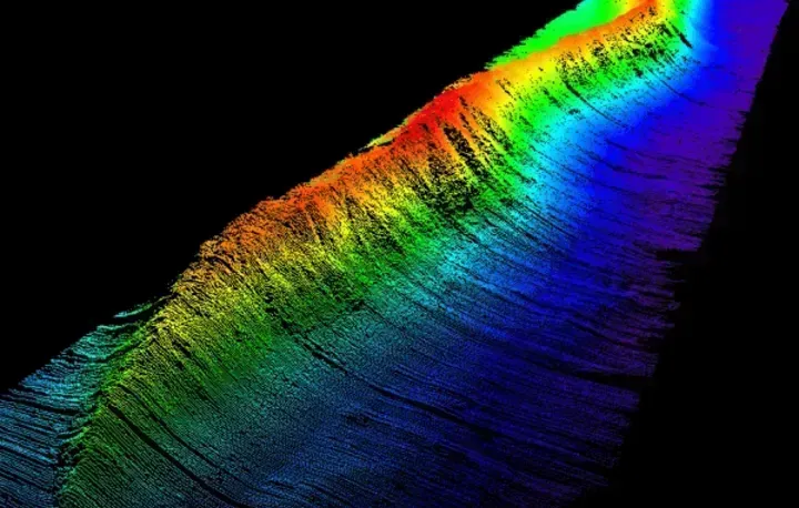
Understanding what lies beneath the surface is fundamental to how we navigate, protect and use the ocean. Hydrography provides the data and insight to help make that possible.
Our team of experts manage and maintain marine geospatial data that helps build this understanding, from seabed mapping da to navigational information used around the world.
What is hydrography?
Hydrography is the science that measures and describes the physical features of the seabed, from our ocean and seas, to our coastal areas, lakes and rivers. As well as underpinning safe maritime navigation, hydrographic data also enables a range of marine activities from environmental protection to marine planning.
Why we map the seabed
We may not spend much time thinking about what lies beneath the surface of the water, but the seabed has a bigger role to play in our lives than we might appreciate.
From ocean conservation to climate change, and from national security to economic prosperity, mapping the seabed enables safe maritime navigation for transportation of 90% of global trade and supports sustainable management of the marine environment.
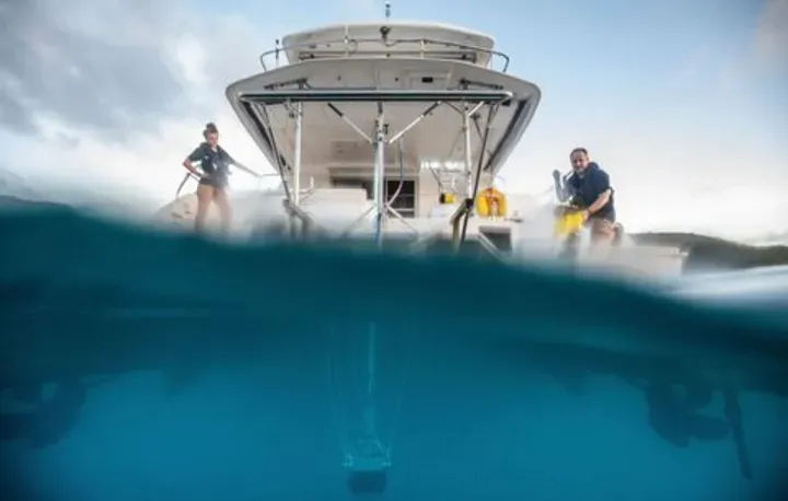
Trusted maritime expertise
We help people make safer, more informed decisions at sea. Our work ranges from navigation products and hydrography to marine data and national security.
Supporting safe navigation
For more than 225 years, the UKHO has supported safe navigation through the Admiralty portfolio of nautical charts, publications and digital navigation services.
Today, over 90% of large ships trading internationally carry our Admiralty products on board to support safe, compliant and efficient navigation.
By trusting Admiralty products and services, ship owners and mariners can be confident they have the latest data to ensure the safety of their vessel, crew, cargo and the environment.
As digital navigation evolves, the UKHO is continuing to develop our portfolio of products so that we can continue to support the needs of mariners – today and into the future.
Global centre for hydrographic understanding
We are a global centre for hydrography, helping to deepen understanding of the world’s ocean through marine geospatial data, seabed mapping and navigational expertise.
We represent the UK internationally, acting as Primary Charting Authority for 63 coastal states and working with UK Overseas Territories and Commonwealth nations to support the management of marine geospatial data.
As the UK government’s centre of expertise on hydrography and seabed mapping, we deliver products and services to support safe navigation in UK waters and help meet obligations under the Safety of Life at Sea (SOLAS) convention.
We work with partners across the marine community to share data and expertise, supporting global challenges and the safe and sustainable use of the ocean.
Marine geospatial data and expertise
Marine geospatial data is essential for almost every activity undertaken in the marine domain. From seabed to surface and from the coast to offshore, our world-class team of experts manage a wide range of data sets.
We utilise cutting-edge technologies to process, analyse and publish data to serve many needs and uses, from safety-critical information for maritime navigation to environmental and scientific research.
Supporting national security
As an executive agency of the Ministry of Defence, providing information to ensure the safety and security of our waters is a vital part of what we do. The Royal Navy and all UK defence vessels, from ships to submarines, rely on the UKHO and our Admiralty products for safe navigation and operational effectiveness.
We work closely with maritime forces and global allies to ensure the best maritime geospatial information is available. This information supports safety and operational decision making around home waters and national infrastructure, international trade routes and the world’s oceans.
Find out more
Discover more about the UKHO – from our history, to the latest news, and opportunities to help shape our future.
Work for us
Looking for your next role? Discover a career opportunity with the UKHO.
We are always looking for skilled individuals to join our team and help shape what comes next. Visit our careers page to find out more about our roles, our specialist teams and what we offer in return as an organisation.
Stay up to date
Explore the latest news, blogs and insights from the UKHO – from maritime operations today, to emerging technologies and the future of navigation.
The UKHO archive
From early hydrographic expeditions to today’s cutting-edge survey techniques, we have collected vast quantities of information throughout our history. Today, the UKHO archive holds hundreds of thousands of historical documents and records, representing one of the most complete maritime collections of its kind.