 Skip to main content

Build what comes next with S-100 data
The IHO testbed brings together industry stakeholders to explore how S-100 can be used in practice and to support development ahead of wider adoption.
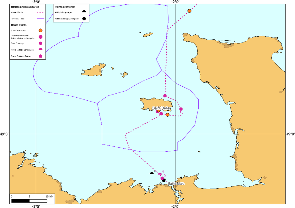
Developed in collaboration between the UK Hydrographic Office and the French Hydrographic and Oceanographic Service (Shom), these data sets form a cross-Channel testbed designated by the IHO to investigate how S-100 standards can be applied in practice. They have been created and exercised through live and simulated sea trials to support industry testing and interoperability.
Feedback from stakeholders and end-users is used to inform the ongoing development of S-100 standards, ECDIS GUI design and future hydrographic data production. The results from the trials will also contribute to the safety case required by the International Maritime Organization (IMO) for the application of S-100 ECDIS.
Discover our S-100 data sets
To support the international testbed project the UKHO and Shom have created S-100 data sets from Southampton and Portsmouth across the Channel to Jersey and down to the Port of St.Malo.
Please note: This data is still under development and is for testing purposes only. It must not be used for navigation.
By downloading the ADMIRALTY S-100 trial data sets, you agree to be bound by the data exploration licence terms and conditions. The S-100 trial data sets contributed by the Shom are subject to the terms of the "SHOM Products Evaluation and Exploration License".
S-100 trial data test scripts
We want your feedback, and to ensure you get the best experience of using the new S-100 data we've created a comprehensive set of test scripts to help guide you through the data sets.
After downloading the data, you will receive an email inviting you to provide feedback via a short survey. Your input supports ongoing development within the international testbed environment.

Download all data sets
Access all S-100 trial data sets for testing. Where applicable, the data sets will be updated on the first working day of the month.
This includes: S-101, S-102, S-104, S-111, S-124 and S-128 data.
S-101 Electronic Navigational Charts (ENC)
S-101 is the product specification for ENCs under the S-100 framework.
The S-101 ENC trial data set has been produced to support ECDIS manufacturers and partners as they develop and test S-100 compatible systems. The coverage aligns with the existing S-57 GB ENC scheme to aid comparison, conformity assessment and interoperability testing alongside other S-100 products.
S-102 Bathymetric surface
S-102 defines high-resolution bathymetric surface data in a regular grid structure.
The S-102 trial data set contains detailed seafloor depth information that can be overlaid with other S-100 layers. When used within compatible systems, this data could support improved understanding of seabed features and depth variation, particularly in confined or complex waterways.
S-104 Water level information for surface navigation
S-104 provides water level information for surface navigation.
The S-104 trial data set includes gridded forecast water levels and astronomical tidal height prediction points. Within compatible systems, this data may support route planning and port entry decision-making by enabling dynamic representation of changing water levels.
S-111 Surface currents
S-111 defines surface current information to an approximate depth of 25 metres.
The S-111 trial data set describes surface current speed and direction, provided in grid or point coverage. When integrated with other S-100 layers, this information could support enhanced situational awareness during voyage planning and navigation.
S-124 Navigational warnings
S-124 is the product specification for navigational warnings under the S-100 framework.
The S-124 trial data set is designed to support testing of machine-readable navigational warnings within S-100 compatible systems, enabling structured display and integration alongside other S-100 data layers.
S-128 Catalogue of nautical products
S-128 defines a standardised catalogue of nautical products, enabling consistent discovery, management and exchange of product metadata within the S-100 environment.
The S-128 trial data set supports testing of catalogue services and interoperability between data producers, distributors and end systems.
S-100 trial data usage licence
UKHO licence
Our Admiralty S-100 trial data sets are available under the terms of the data exploration licence.
By downloading the Admiralty S-100 trial data sets, you agree to be bound by these licence terms and conditions.
The data sets are provided for testing purposes only and are not to be used for maritime navigation.
SHOM licence
The S-100 trial data sets contributed by the Shom are subject to the terms of the "SHOM Products Evaluation and Exploration License".
Please review the applicable terms before downloading.
S-100 data specifications
Please refer to this document for the cell name, edition and file size of the S-100 product specifications from the UK Hydrographic Office and SHOM.
International testbed partners


Explore the S-100 trials programme
Discover how we are collaborating to test S-100 in operational scenarios through live sea trials and simulated testing. Each trial will contribute to the International Hydrographic Organizations’s efforts to validate data standards and address operational use cases across key maritime routes and partnerships.
S-100 timelines explained
Understand the S-100 timeline: from the introduction of the IMO Performance Standards to the expected dual-fuel ECDIS era. Discover what these dates mean for ship operators, mariners and ECDIS manufacturers. Stay informed with this definitive guide from the UK Hydrographic Office.
Subscribe to keep updated on S-100
If you would like to keep updated on the UKHO's latest developments with regards to S-100 standards and the next generation of navigation, subscribe using the link below.
Harnessing the next generation of navigation solutions
S-100 is a new data framework that will underpin the next generation of navigation technologies. Discover how the next generation of data standards will transform the way decisions are made from ship to shore.