 Skip to main content
Maximising access to bathymetry data and putting the user first
30 June 2022
Our legacy as seabed mapping experts
As part of our commitment to support safe, secure and thriving oceans, we have extensive seabed mapping data and services to support marine decision-making. These include wide-ranging data sets from seabed to surface, including bathymetry and seabed profiles, seabed geology and seabed samples and pipelines, cables and subsea infrastructure - gathered through close collaboration with expert providers, government organisation, hydrographic offices and other partners around the world.
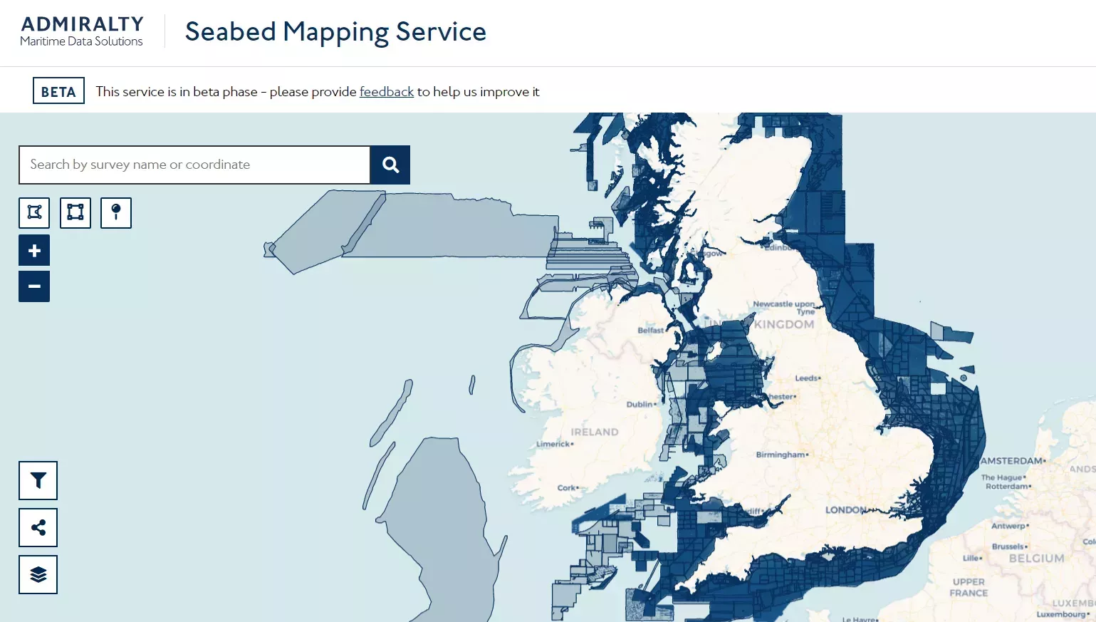
As an organisation with a public duty to fulfil, we remain highly committed to making the marine environmental data sets that we hold more available and accessible for users, and more useful for decision-making affecting the marine environment. This is why, today, we are excited to present the new Seabed Mapping App, a web-supported portal for users to access the extensive UK bathymetry holdings held within our Marine Environmental Data and Information Network (MEDIN) accredited National Data Archive, and download bathymetry data which is freely available under the UKHO Bathymetry Data Licence (similar to an Open Government Licence or OGL).
The new Seabed Mapping App – facilitating user access to the highest quality marine data
The Seabed Mapping App is part of our Seabed Mapping Services, which was made available via our ADMIRALTY Marine Data Portal two years ago as a Beta version. Since then, we have been working closely with various user groups – academia, government and commercial companies - to gather their feedback and continually test and improve the service, which supports The Nippon Foundation-GEBCO Seabed 2030 Project and the launch of upcoming UKHO-led projects in this space, as well as reinforcing the UKHO’s voice as a UK and international authority in bathymetry. We currently offer over 6,000 surveys covering 261,604 km2, 36% of the UK seabed, and receive over 9,000 downloads per year by nearly 3,000 users.
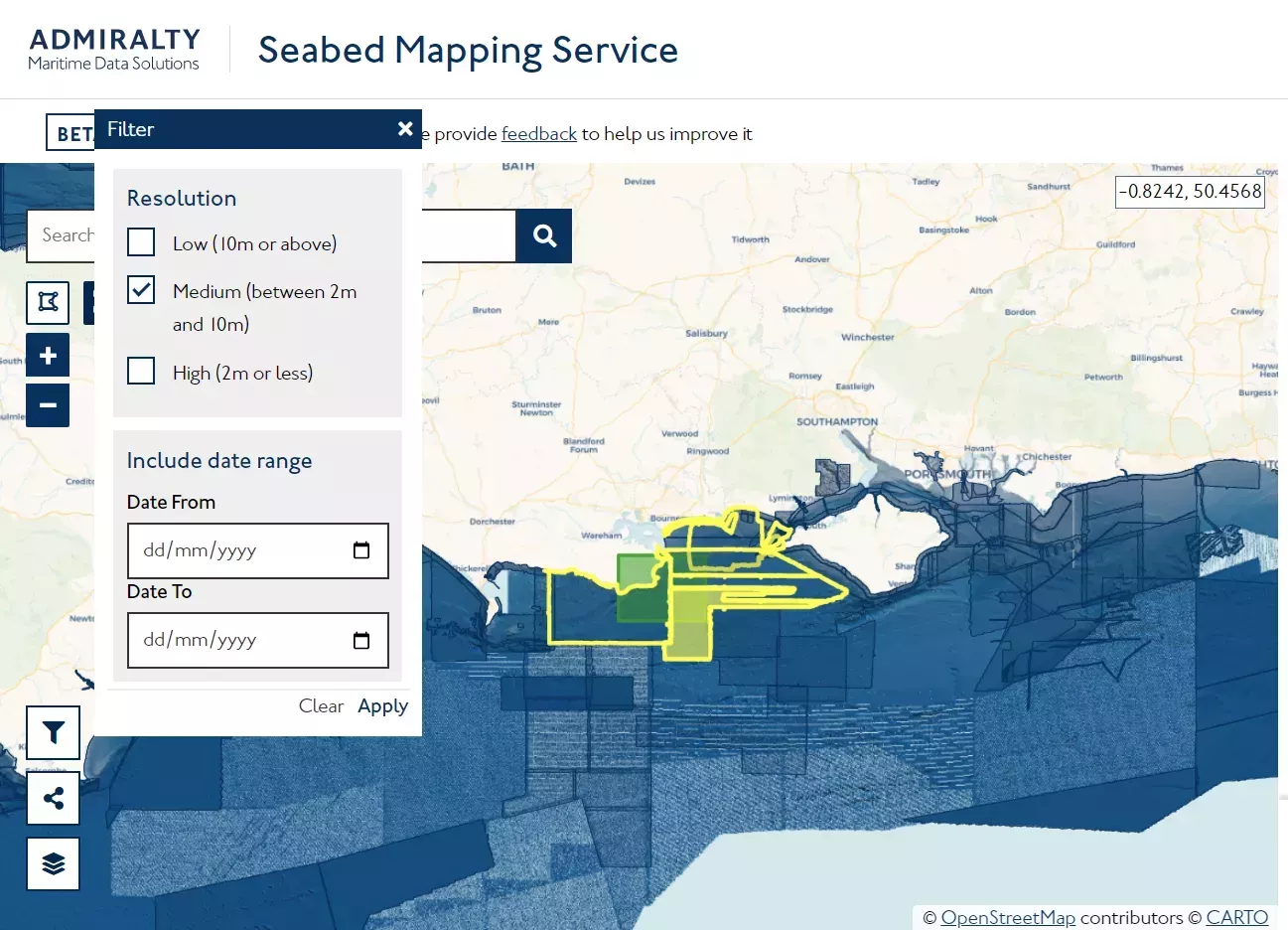
Guided by feedback from different user groups, we have improved the interface of the app and added new services, including a web map tile which provides context and helps users identify the data sets they want to download. By providing a visual backdrop and elevating the Digital Elevation Model of the seabed, users gain a better understanding of the available surveys, which helps them choose which one/s to download.
The Seabed Mapping App has also seen the addition of new filtering tools following different criteria - such as the survey capturing date and data resolution - resulting in a much quicker narrowing down of users’ data set search and a more streamlined download. Additionally, we have conducted substantial work across our 6000 data sets of cleansing the data, standardising the content, improving the titles, abstracts, and the metadata content, supporting the rollout of the latest MEDIN Discovery Metadata Standard. This metadata standard is a marine profile of the UK Government Standard GEMINI2 and complies with other international conventions such as INSPIRE and ISO19115. More information on this can be found on the MEDIN website.
Following these adjustments and improvements, the new Seabed Mapping Service has become a fully fit for purpose, 21st century digital data archive which is a real asset for the UK as a whole and for marine academia, public and private sector communities to take advantage of, with the UKHO acting as a custodian and enabler of the most accessible, advanced and cleansed bathymetry data sets.
If you would like to try the Seabed Mapping App, visit our Beta Seabed Mapping Data Service page. We continue to collect feedback from users on an ongoing basis and are constantly improving and making the necessary adjustments to our services. If you would like to share your thoughts and opinions, please email products.feedbac@ukho.gov.uk.
If you would like to know more about the rest of our other Seabed Mapping Services, visit our Seabed Mapping Service page.