 Skip to main content
To enhance safety and precision for mariners, new ‘high density’ Electronic Navigational Charts (HD ENCs) are available through ADMIRALTY Vector Chart Service (AVCS).
After publishing a number of GB HD ENCs, we have now made available a further eleven HD ENCs containing 1m and 0.5m contouring in navigationally significant and strategically important areas:
|
Coverage |
HD ENC |
|---|---|
|
Coverage Sunk Deep Water Route, Thames Estuary |
HD ENC GB4H0002 |
|
Coverage Long Sand Head, Thames Estuary |
HD ENC GB4H0003 |
|
Coverage Inner Sunk Deep Water Route, Thames Estuary |
HD ENC GB4H0001 |
|
Coverage Tail of the Falls, Dover Strait |
HD ENC GB4H0004 |
|
Coverage Shipway Channel, Orford Ness |
HD ENC GB4H0005 |
|
Coverage Lima Anchorage, Firth of Forth |
HD ENC GB5H0002 |
|
Coverage Oban, Scotland |
HD ENC GB6H0001 |
|
Coverage Kyleakin Pier, Scotland |
HD ENC GB6H0003 |
|
Coverage Bristol Bridge Patch |
HD ENC GB6H1176 |
|
Coverage Port Villa, Vanuatu |
HD ENC GB6H0002 |
|
Coverage Milford Haven, Wales |
HD ENC GB5DEQSC, GB5DEQSA, GB5DEQSD, GB5DEQSE |
This follows customer feedback and user research from the UK Hydrographic Office (UKHO) showing the demand for additional bathymetric contouring in high traffic areas and more dynamic areas of seabed.
What are HD ENCs?
Contoured at one-metre intervals, HD ENCs provide users with the ability to choose the most appropriate safety contour for the draught of their vessel, enabling them to visualise navigable waters in ECDIS more clearly.
For example, shown below is the navigable area for a vessel with a draught of 7m, where the default safety contour is 10m.
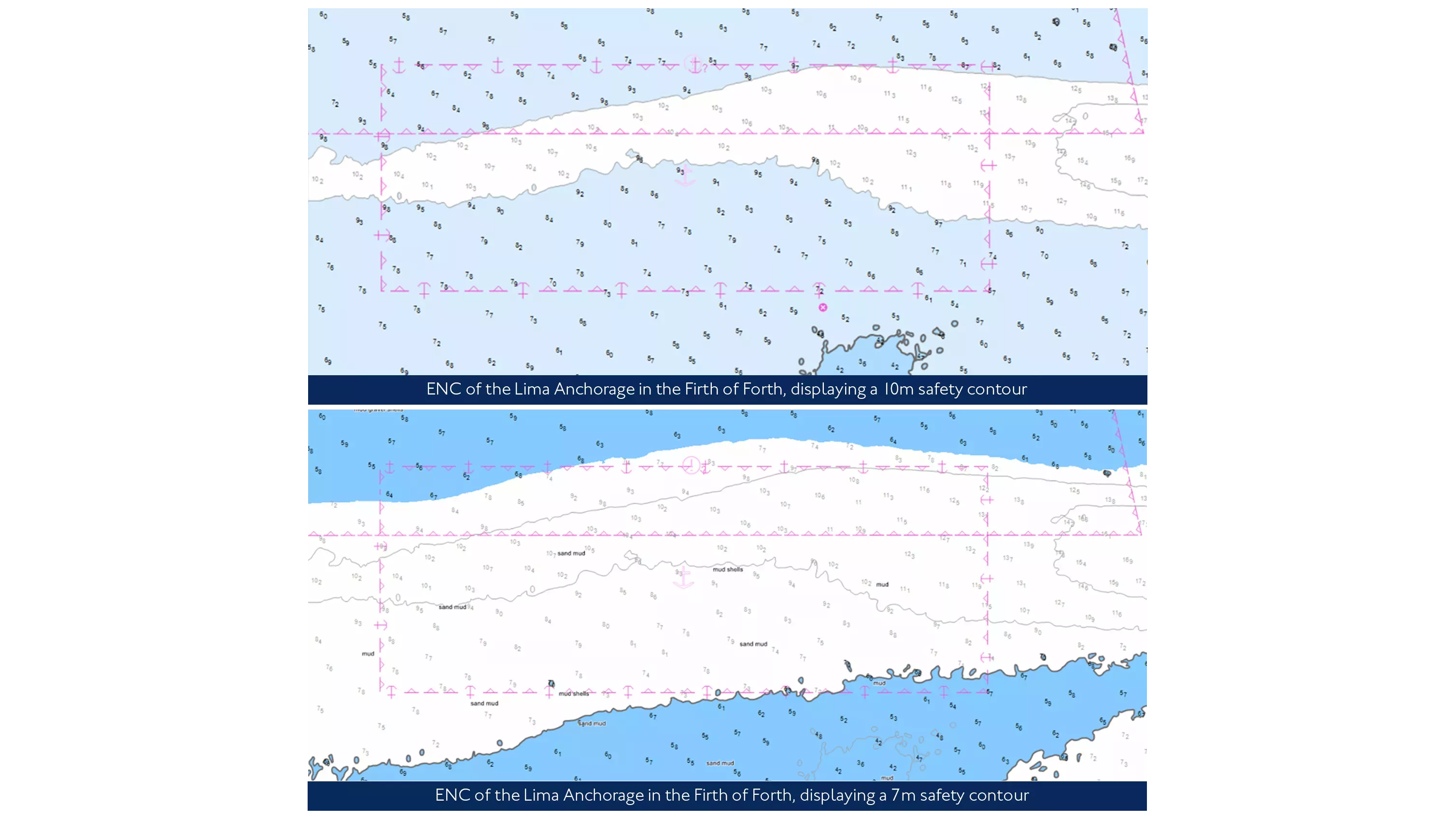
With a HD ENC contoured at 1m intervals, the user now has the ability to select a 7m safety contour, enabling them to visualise safely navigable waters in the same area (as shown above).
These ENCs are compiled using highly accurate bathymetric data and verified by the UKHO’s skilled cartographers to confirm accuracy. The ENC is then created and published in compliance with the strict international standards for production of HD ENCs.
What are the benefits of HD ENCs?
HD ENCs with additional bathymetric contouring can bring significant safety enhancements to pilots and mariners when displayed in ECDIS and Portable Pilot Units (PPUs), particularly when navigating in areas of confined or shallow waters.
With most charts containing depth contours at intervals of 2m, 5m, 10m, 20m and 30m, ECDIS can often set a safety contour at a deeper interval than the value set by the user. This means that the mariner will sometimes have to cross the safety contour and override ECDIS alarms, which not only results in administrative burden and alarm fatigue, but also increases risk if the ship is actually approaching depths of insufficient under-keel clearance. With HD ENCs, mariners are able to set the appropriate safety contour, allowing them to navigate with much greater precision, efficiency and confidence.
In addition to important safety benefits, HD ENCs can also bring economic benefits to cargo owners and ship operators. With greater precision of the true depth of water under the keel, vessels are able to optimise their cargo carrying capacity and logistical planning.
While HD ENCs will provide immediate safety enhancements when displayed in ECDIS using the current standard (S-57), this work is being completed in readiness for emerging products underpinned by the International Hydrographic Organization’s S-100 standards. This includes the development of S-101 (the next technical generation of ENCs that will supersede S-57) with new ECDIS performance standards being introduced from 2026.
When will more HD ENCs be made available?
The UKHO is continuing to work with ports and industry partners to develop additional HD ENCs which will be made available through AVCS, ensuring users are at the centre of products and services provided. This work forms part of a wider data improvement project to bridge the gap between standard ENCs and high-density coverage.
Read more on this topic
Search Title
Understanding ECDIS alerts: How to reduce alarm fatigue
For most navigators, the sound of an ECDIS alert is unmistakable. Depending on the watch, an ECDIS alert can mean anything from a routine chart update to an imminent grounding risk. The challenge is knowing which is which – and acting accordingly.
Search Title
Why ECDIS training remains critical for safe navigation
New data from NorthStandard highlights where bridge teams are confident with ECDIS and where understanding can be strengthened.

Search Title
Sustaining the future of ADMIRALTY Standard Nautical Charts
To ensure continued access to paper charts, the UK Hydrographic Office (UKHO) is evolving how ADMIRALTY Standard Nautical Charts (SNCs) are produced. This supports long-term sustainability of the portfolio while maintaining the safety, compliance and coverage mariners need.