 Skip to main content

As part of the emerging S-100 data framework being introduced by the International Hydrographic Organization (IHO), a range of new product specifications are under development to enhance the way maritime data is shared, displayed and used.
Body"For every additional 10cm of water that's been identified through S-100 data, a terminal could load around 100 extra containers."
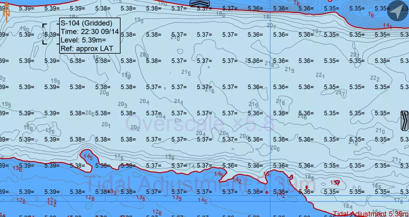
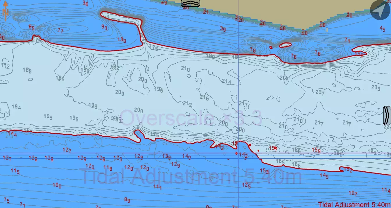
In our sea trial with the Port of London Authority, these dynamic contours were displayed in the SEAiq viewer and automatically adjusted in line with the latest tidal forecasts. This helped inform decisions like when to begin berthing or how best to plan for tight river manoeuvres, because pilots could visualise tidal height in relation to the seabed across different parts of the river.
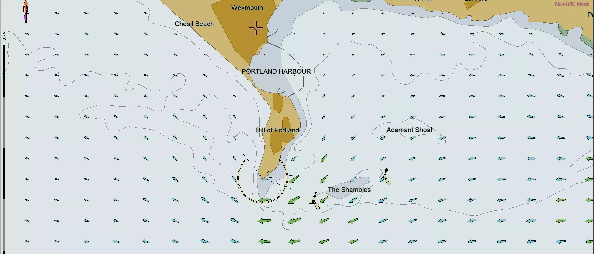
S-111 datasets offer high-resolution gridded current speed and direction data. During the PLA sea trial, these were used to improve the accuracy of predicted vessel drift across the tide and inform Master-Pilot Exchange (MPX) briefings. Tidal shear and eddy zones, which were previously hard to anticipate, were clearly visible, allowing for more accurate route planning and timing of manoeuvres.
Optimising a vessel’s interaction with surface currents could reduce engine output needed for course correction, contributing to better fuel efficiency and lower emissions, especially important in congested or environmentally sensitive port approaches.
Body"Although you're viewing three different products, all that's actually happening is your safety contour is moving in and out. The user isn't overloaded - they're empowered."
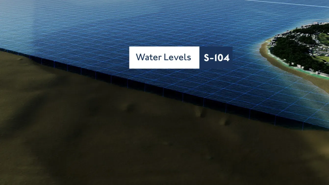
S-104: Water levels
- Replaces single-point tidal predictions with a dynamic gridded surface
- Supports dynamic under-keel clearance calculations by allowing ECDIS to reflect tidal height changes over time
- Helps extend tidal windows, reduce waiting times, and optimise loading limits
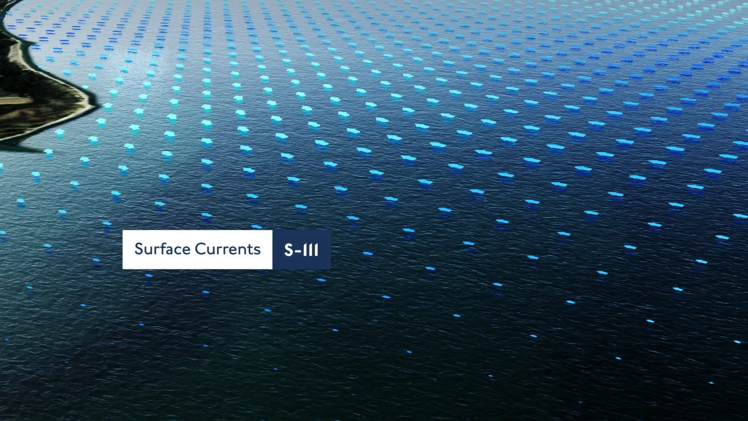
S-111: Surface currents
- Provides current speed and direction in high-resolution grids
- Enables more accurate drift forecasting and route planning
- Supports reduction of unnecessary engine power and fuel consumption
These datasets enhance both safety and efficiency, particularly in challenging, tidal or heavily trafficked ports.
Port of London at a glance
- Over 50 million tons of cargo handled annually
- ~20,000 vessel movements per year
- 70+ terminals
- Compulsory pilotage for ~50% vessels
- Susceptible to surges
- Fast flowing with tight bends that make it challenging to navigate
The UK Hydrographic Office (UKHO) collaborated with the Port of London Authority (PLA) to test the applications of S-104 and S-111.
Key outcomes from the PLA sea trials of S-104 and S-111
Our sea trials with the PLA revealed the following benefits:
- Improved master-pilot communication: Real-time tidal stream data (S-111) allowed pilots to show ships’ masters predicted drift during berthing, enhancing shared situational awareness.
- Shoreside planning: Forecast data was shared with duty port controllers, helping to optimise vessel movements and port resource allocation based on accurate, time-specific tidal conditions.
- Safety and confidence: Combining S-104 with bathymetric data gave greater assurance over minimum depths during transits, helping extend tidal windows or reduce waiting times.
- Technology readiness: The trial confirmed that S-100 is shaping the future of navigation. Tidal models and datasets can be generated; visualised in platforms like SEAiq, and used effectively, though automation and data handling improvements were identified as next steps.
Body"With dynamic under-keel clearance, owners and charterers can avoid unsafe port disputes - you've got the data to back it up."

Name
Simon Hampshire
As Product Manager at the UKHO, Simon leads on the implementation of new S-100 standards for tidal water levels and surface currents data (S-104 and S-111), as well as contributing to the development of bathymetric products under S-102. His work supports the future of safe, data-driven maritime navigation by aligning user needs with technical delivery and strategic priorities.
Simon brings deep expertise in geospatial services, digital transformation and maritime data products, developed across two decades in government and defence sectors. He plays a key role in shaping the UKHO’s product roadmap for next-generation navigation, working with stakeholders across industry to enable the adoption of innovative, standards-based solutions.
What's next for navigation?
S-104 and S-111 are just two of several interoperable data sets within the S-100 framework which are already being tested to see how they can enhance port operations, voyage planning and environmental performance, especially in conjunction with S-101 (ENC) and S-102 (bathymetry).
If you're interested in testing datasets, including S-104 and S-111, or if you'd like to learn more about S-100, you can access our trial data and watch our S-100 webinar by following the links below.
Watch our webinar
If you'd like to learn how S-100 is helping shape the next generation of digital navigation, watch our webinar - Shaping the future of navigation with S-100.