 Skip to main content
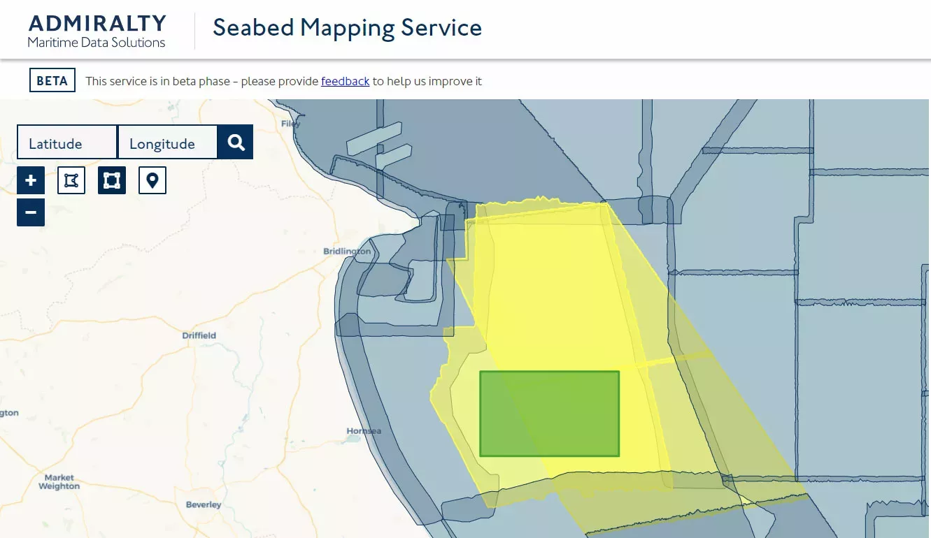
A beta service developed with agile principles will bring vital seabed data closer to the user through the ADMIRALTY Marine Data Portal.
As a world-leading marine geospatial data provider, we hold vast amounts of data through our seabed mapping expertise. The data we hold ranges from the seabed to the coast, offshore and beyond, with extensive data on bathymetry, wrecks and obstructions, along with a range of apps and APIs available through the ADMIRALTY Marine Data Portal. With this data and the rich picture that it paints of the marine environment, we can help users make more informed decisions to support a safe, secure and thriving future for the blue economy.
The Seabed Mapping Service gives users access to data that has been collated, processed and validated by UK Hydrographic Office (UKHO) experts, helping create the right bathymetry data output to meet your needs. The service has been developed using agile project management principles and launched as a beta service. This means that we will be continually testing and improving the service, ensuring it fulfils user needs.
When developing products and services, we place a strong emphasis on designing a good user experience, which is why beta testing is so valuable. As a beta service, it is fully available for use, while inviting and encouraging users to submit feedback about the service’s usability and suitability to meet their needs. Our teams will gather this feedback, analyse it closely and make gradual adjustments with each iteration, aligning the service closer to the user needs and supporting a more seamless user journey.
Body“At the UKHO, we pride ourselves on helping meet the evolving needs of existing customers as well as users in new markets. We encourage feedback and input from users on our Seabed Mapping Service. Through this, we will help people make better use of the marine environment and our blue economy through sustainable decision-making based on detailed seabed information.”
The digital landscape in the marine and geospatial ecosystem is constantly evolving and user needs continue to change. The addition of the Seabed Mapping Service to the ADMIRALTY Marine Data Portal and making data more accessible for users and more useful for decision-making is a core strategic focus for the UKHO.
We are members of the Marine Environmental Data and Information Network (MEDIN), a partnership of UK organisations committed to improving access to UK marine data. In addition to the Beta Seabed Mapping Data Service, which provides bespoke data sets, users can also explore and download the extensive UK bathymetry holdings within our MEDIN accredited archive and download bathymetry data which is freely available under an Open Government Licence.
You can find out more about our seabed mapping expertise and services on the ADMIRALTY Marine Data Portal.
Read more on this topic
Search Title
Understanding ECDIS alerts: How to reduce alarm fatigue
For most navigators, the sound of an ECDIS alert is unmistakable. Depending on the watch, an ECDIS alert can mean anything from a routine chart update to an imminent grounding risk. The challenge is knowing which is which – and acting accordingly.
Search Title
Why ECDIS training remains critical for safe navigation
New data from NorthStandard highlights where bridge teams are confident with ECDIS and where understanding can be strengthened.

Search Title
Sustaining the future of ADMIRALTY Standard Nautical Charts
To ensure continued access to paper charts, the UK Hydrographic Office (UKHO) is evolving how ADMIRALTY Standard Nautical Charts (SNCs) are produced. This supports long-term sustainability of the portfolio while maintaining the safety, compliance and coverage mariners need.