 Skip to main content



Explore how structured navigational warning data could help bridge teams understand hazards and activities in the context of their passage.
What is S-124?
S-124 is the International Hydrographic Organization’s (IHO) product specification for encoding navigational warnings as structured, machine-readable data. Part of the S-100 framework, it is designed for use in compatible Electronic Chart Display and Information Systems (ECDIS).
Navigational warnings provide urgent information relevant to safe navigation, from an unlit aid to navigation or a drifting hazard to an offshore activity.
The loss of 16 containers from Baltic Klipper near the Isle of Wight in December 2025 illustrates the importance of clear warning information. The potential collision risk led to a temporary closure of the Solent deep-water channel. In situations like this, S-124 will help bridge teams understand the geographical extent of a warning and its relevance to their planned passage by presenting the information alongside the chart in compatible ECDIS.
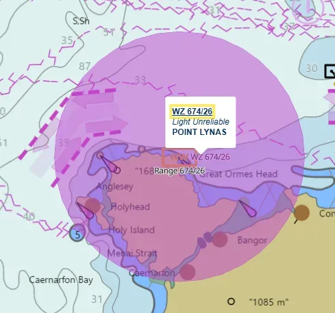
Image opposite shows S-124 navigational warning relating to a light signal.
How will S-124 differ from existing navigational warnings?
Today, navigational warnings are delivered through established broadcast services, including NAVTEX and satellite-based Enhanced Group Call (EGC). Bridge teams read the messages, identify those relevant to their voyage and plot information when required.
These textual warnings follow agreed conventions for communicating essential information. S-124 provides a structured, machine-readable representation of that information, with defined fields that compatible navigation systems can process alongside the warning text.
For example, a warning about cable-laying operations could include the location and extent of the activity, its expected start and end times, and a request for vessels to give the operation a wide berth. In S-124, information about location, warning type, timing, restrictions and affected areas can be encoded as structured data, while retaining useful accompanying warning text.
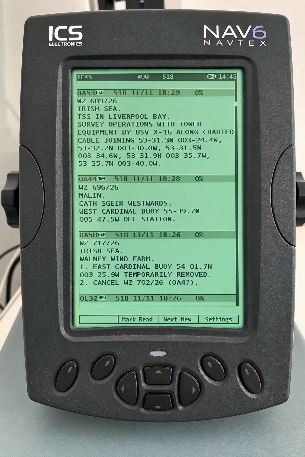
Image opposite shows a typical NAVTEX receiver, a maritime device that automatically receives and prints or displays Maritime Safety Information (MSI)—including navigational warnings, weather forecasts, and urgent safety alerts—broadcast on standardized frequencies such as 518 kHz and 490 kHz.
What are the potential benefits of S-124?
By bringing structured warning information into ECDIS, S-124 could help bridge teams identify relevant hazards and assess their implications for safe navigation.
A warning’s relevance depends on more than its position. Mariners also need to understand the nature of the hazard, the area it affects and when it applies. S-124 allows these details to be encoded so that compatible navigation systems can help present the information in context.
For bridge teams, this could make it easier to connect an individual warning with the passage they are planning or monitoring. The aim is to support their assessment by making essential information easier to locate and interpret.
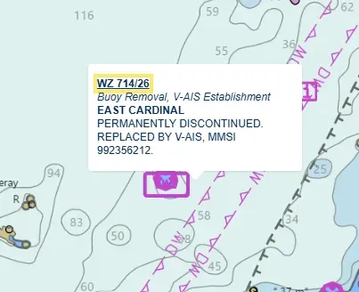
Image opposite shows S-124 navigational warning with further details of a discontinued cardinal marker buoy.
Clearer geographical context
Displaying navigational warnings alongside the Electronic Navigational Chart (ENC) could make it easier to understand the location and the extent of a hazard or activity in relation to a vessel’s planned passage.
A drifting hazard or offshore operation could be represented using the appropriate point, line or area geometry. This could help bridge teams assess the warning’s relevance without first having to transfer its geographical information manually from a separate text message.
More information about the area affected
The position of a feature does not always describe the full area over which its effects may be relevant to navigation.
For example, an unlit aid to navigation may be relevant to vessels some distance from its charted position. Similarly, a radio service outage may affect vessels throughout the area normally served by the transceiver.
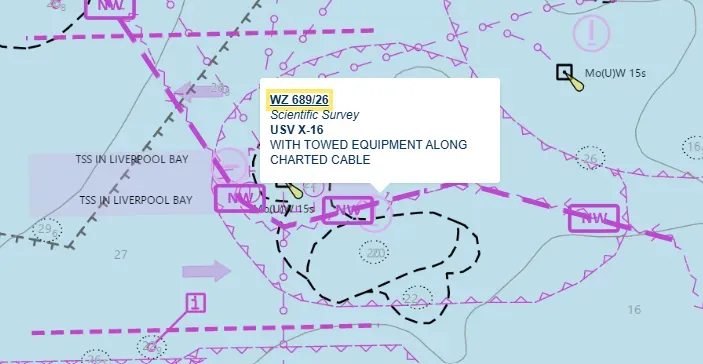
Image opposite shows S-124 navigational warning with details of surveying activity including towed equipment.
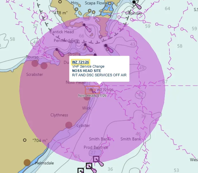
Where appropriate information is available, S-124 can distinguish between the position of the feature and the area affected. This gives navigation systems additional information to help identify warnings relevant to the vessel’s passage.
To avoid unnecessary clutter on the navigation screen, the affected-area feature is not displayed as part of the normal portrayal. Instead, the system highlights it when the mariner selects it from a pick report to examine its geographical extent.
Testing will help establish how this information can best support mariners’ assessment of warning relevance.
Image opposite shows S-124 navigation warning with details of a radio service interruption.
Near-real-time warning information
Navigational hazards can emerge at short notice, making timely information essential. S-124 is designed to support near-real-time updates, helping bring newly issued warnings into the navigational picture as conditions change.
Realising this benefit will depend on reliable distribution and integration with onboard systems. Timely, consistent delivery alongside existing text warnings is an important consideration as S-124 services are developed.
Time-specific information
Some navigational warnings concern activities that take place within a defined period, such as survey work or cable operations.
Where these times are known, S-124 allows them to be encoded as part of the warning. This gives compatible systems information about when an activity is expected to take place. Where supported, compatible systems could filter warnings by the date range of the hazard and the valid time of the warning, helping mariners assess their relevance to an intended passage. The expected timing of an activity does not necessarily define how long its warning remains valid.
Less manual transfer of information
Displaying warning information within ECDIS could reduce the need to transfer geographical information manually and help bridge teams consider warnings alongside the ENC and other S-100 data sets.
Mariners would still need to read the warning details and assess their implications. The potential benefit is easier access to relevant information within the navigational picture they are already using. Integrating warnings into ECDIS could also reduce the need to consult separate displays when assessing their relevance to a passage.
How is the UKHO supporting the development of S-124?
The UK Hydrographic Office (UKHO) fulfils the roles of NAVAREA I Coordinator and UK National Coordinator, coordinating navigational warnings for its international area of responsibility and UK coastal waters.
Our watchkeepers assess incoming information to determine whether a warning is needed. They prepare warnings for the appropriate broadcast areas, monitor their status and cancel them when required. This operational experience informs our preparations for S-124, including the need to maintain consistency between conventional text warnings and their S-124 equivalents throughout the warning lifecycle, from initial issue through updates and cancellation.
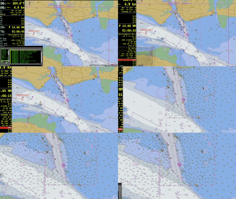
The UKHO has developed the capability to produce both outputs within a shared workflow. We are also creating S-100 test data sets for our S-100 trials programme. S-124 warnings have been tested during a S-100 simulator trial at ECDIS Ltd, helping us explore how structured warnings information can be presented within navigation systems and used by mariners.
Clip shows the moment a navigational warning is detected and displayed on a prototype S-100-enabled ECDIS.
What will the transition mean for mariners?
The introduction of S-124 does not immediately replace existing navigational warning services or bridge procedures. Existing approved Global Maritime Distress and Safety System (GMDSS) arrangements will continue to provide the means of meeting applicable International Convention for the Safety of Life at Sea (SOLAS) requirements for receiving Maritime Safety Information. In future, S-124 services may be recognised as a means of meeting these requirements, subject to the necessary international regulatory approvals.
Mariners should continue to receive and use warnings through existing approved arrangements, including reading and plotting information as required. Access to S-124 data does not, by itself, replace those arrangements or responsibilities. Producing structured warning data is one part of the process. Reliable distribution, compatible onboard equipment and the consistent presentation of information are also essential. For urgent navigational warnings, timely delivery is particularly important.
Continued development and testing will help establish how S-124 services can support bridge teams alongside existing arrangements.
What's next for navigation?
Navigational warnings are relevant to vessels of all types, and the hazards and activities they describe can affect vessels throughout a voyage. While some S-100 capabilities offer potential benefits in shallow or constrained waters, hazards and activities covered by navigational warnings can affect vessels throughout a voyage.
Alongside S-101 Electronic Navigational Charts and other interoperable S-100 products, S-124 will help bring this essential safety information into the navigational picture.
A similar approach is being developed for marine weather warnings through the World Meteorological Organization’s S-412 product specification. By representing areas affected by hazardous weather alongside chart information, S-412 could help mariners assess potential impacts on their route and passage timing. Although less mature than S-124, it illustrates the wider potential for bringing safety information onto the bridge.
Sign up to our S-100 email newsletter below to receive regular updates and resources on S-100 or explore S-100 now and learn more about the transition ahead.

Name
George Goody
George Goody is the Maritime Safety Information (MSI) Technical Lead at the UK Hydrographic Office (UKHO), where he also serves as the NAVAREA I Coordinator and UK National Coordinator. He is responsible for coordinating the assessment and promulgation of navigational warnings in support of safe navigation across the North-East Atlantic and adjacent waters.
With a professional background in seagoing navigation, George brings practical maritime experience to his work in MSI. He is actively involved in the international development and implementation of the S-100 framework, particularly S-124 Navigational Warnings, helping to ensure the transition to structured digital navigational warnings meets the needs of mariners.
Read more on this topic
Search Title
Take S-100 above and beyond navigation with UKHO and ESA
Explore ESA funding opportunities and UKHO S-100 data to develop space-enabled maritime services. Watch the launch webinar and access the data to support your innovation.
Search Title
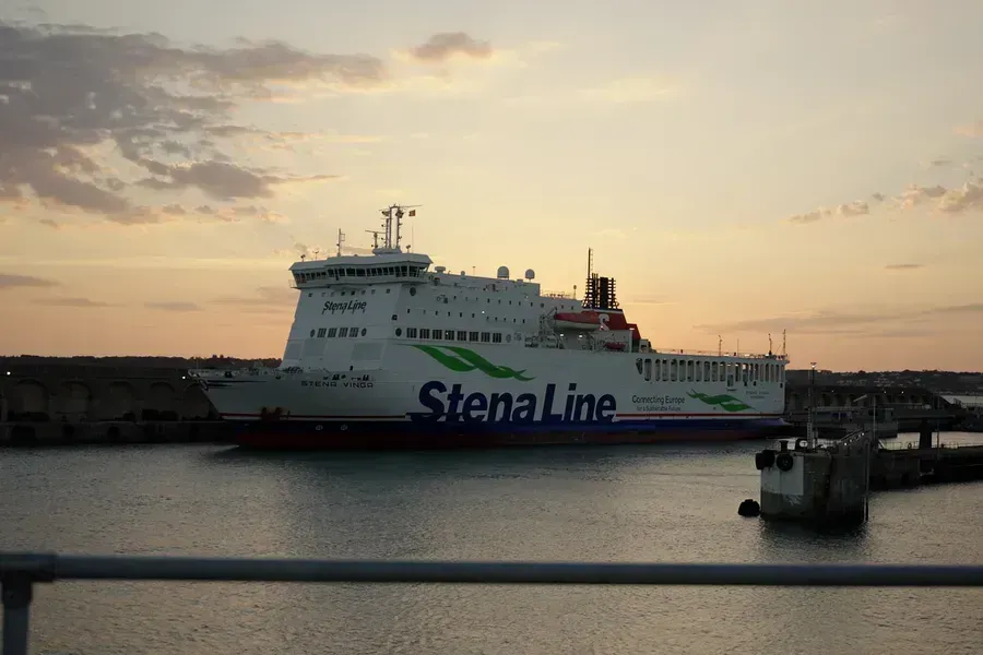
Inside the trials: testing S-100 aboard Stena Vinga
What happens when emerging S-100 data and technology move from the simulator environment onto the bridge of a working vessel? A sea trial aboard Stena Vinga put S-100 to the test on a challenging passage between Portsmouth and St Helier, Jersey, helping the UK Hydrographic Office and its partners better understand how S-100 can be developed to meet the needs of mariners.
Search Title
S-100: your questions answered
Across recent UKHO webinars and industry events, several questions have appeared repeatedly. Here, we address some of the most common and look at what mariners and operators need to know at this stage of the transition.